
Trace a Marquette Street Address
The usable trail begins with a current, normalized Marquette address. Keep the house number, directional prefix, street name, and suffix together, then use the address in the Marquette County parcel tools. A property address is also called a situs address. It identifies the land. The address where a Marquette tax bill is sent is a mailing address, which can be different. Neither proves that a particular person is physically present. The most reliable Marquette street directory work connects a parcel to recorded land documents and then adds dated historical sources.
- Search the Marquette address in Marquette County's BS&A public search. Record the parcel number, the situs address, and any legal-description details the live card displays.
- Find the same Marquette parcel in the Marquette ViewPro map. Save the PIN, the displayed street label, nearby intersections, and the parcel geometry.
- Separate the situs from any mailing address. A different mailing address only shows where tax correspondence goes, not who occupies the property.
- Use the Marquette parcel's legal description and current owner to search the Marquette County Register of Deeds index. Read the current grantee, then follow each earlier grantor backward.
- For an individual current-registration check, use Michigan Voter Information Center with the required name, birth month, birth year, and registration ZIP. It is not a street roster.
- For older households, compare an appropriate directory year, newspaper residence reference, or historic map with the deed date. The local collections are stronger evidence for a past address than a modern parcel card alone.
The order matters. A current Marquette name can be searched as a grantee, while a legal description can bridge a deed that never uses the present house number. If the question is about a whole named Marquette road rather than one address, repeat the parcel-and-deed sequence one parcel at a time instead of assuming contiguous parcels share a household.
Marquette Street Directory Search Fields
The general Marquette BS&A route advertises Address, Name, and Parcel Number searches. It also shows categories for current tax, building-department records, delinquent tax, animal licenses, and detailed records. These choices make it a useful starting point for a Marquette address search, but the county describes the information as reference-only. The published material does not confirm the card fields, a coverage year, exact partial-match behavior, or a ZIP filter. The county-specific Equalization link returned an access error during research, so use the general route and confirm any live result with the county or municipality.
| BS&A field or route | Input | Published use | Limit to keep in mind |
|---|---|---|---|
| Address | Text search | Search a Marquette situs or street address | Exact and partial behavior is not stated |
| Name | Text search | Search an owner, person, or business name | A result is not proof of occupancy |
| Parcel Number | Text search | Use the Marquette parcel or PIN as the land key | County format is not published |
| Current tax | Category link | Open Marquette current-tax records | Coverage year is not published |
| Building department | Category link | Reach Marquette permit and inspection records | Live result fields were not captured |
| Delinquent tax, animal license, detailed record | Category links | Additional advertised record routes | Not a ZIP-based street browse |
Use the Marquette website's advertised keys, then preserve what the actual result shows. Do not fill in missing details from a similar parcel. The Marquette public description supports an address, name, or parcel search, not a promise that every record type has the same dates or fields.
Read a Marquette Street Map
The Marquette ViewPro viewer supplies the map context that an assessment search cannot. After its disclaimer is accepted, the documented choices are Parcel Search, Intersection Search, and Coordinate Search. Parcel Search accepts a PIN, an owner name, or a street address, then opens a results panel. Some parcel information may require payment, and the complete layer list was not captured. The map is still useful for seeing the Marquette parcel outline, adjoining lots, road frontage, intersections, and the standardized street label.
Use the Marquette viewer to orient the record trail, not to identify occupants. A shape on a Marquette map can show that two Marquette lots meet or face one another. It does not establish who lives in either building. The PIN is the better handoff to BS&A, and the legal description is the better handoff to the deed index.
Insider tip. When a Marquette address does not return a map match, try its PIN or the nearest intersection, then copy the map's standardized street name into the next search.
Marquette Address Records by Street
Marquette address-keyed sources answer different questions. Marquette parcel and tax material ties a location to assessed ownership and land identifiers. Marquette deeds document recorded parties and transfers. Building records can document work at an address. Historical directories, newspapers, maps, and photographs can place a person or structure at an earlier point in time. Keeping those distinctions visible avoids turning a Marquette street directory into an unsupported list of current residents.
| Address record | What it can establish | Marquette access route | What it cannot establish alone |
|---|---|---|---|
| Parcel and tax record | PIN, situs, assessed owner, tax context, mailing address if shown | BS&A address, name, or parcel search | Current household membership |
| GIS parcel map | Marquette parcel shape, boundary, road, intersection, adjoining lots | ViewPro interactive map | Occupancy or a complete owner history |
| Deed and mortgage index | Recorded parties, instrument trail, date, legal description | Marquette Register of Deeds online and counter | Continuous residence |
| Building permit | Address, PIN, permit or record number, work history if released | Marquette County Building Codes and BS&A | Who resides there now |
| Zoning or engineering file | Land-use, application, right-of-way, or infrastructure context | City Community Development and FOIA request | A public resident list |
| Historic directory, newspaper, map, or photo | Dated address or building context | PWPL and Marquette Regional History Center | A current address match |
The Marquette parcel number is the joining key. Street spelling starts the search, the PIN anchors the land, and the legal description helps when older records use a lot or block instead of a familiar street number.
Marquette Street Tax Roll History
Assessment rolls can add an older land-and-tax snapshot to a Marquette address trail. The Archives of Michigan lists Marquette assessment rolls from 1868 through 1940, plus later Marquette tax-roll runs in separate record groups. An assessed party can help place Marquette ownership or tax responsibility in a given year, especially when a deed or directory leaves a gap. It is still not an occupancy record, and its year should stay attached to every note.
Use the Archives of Michigan finding-aid route, Marquette County access, or local research collections to locate the relevant run. A historic Marquette street directory entry, an assessment record, and a recorded deed can reinforce one another when they share the same lot, block, parcel description, or careful street-name bridge.
Follow a Marquette Deed Chain
The Marquette Register of Deeds is the official county recording office. Its page says Marquette land records date to the 1800s, but the online deed index and images begin January 1, 1980. Mortgage and miscellaneous records begin online January 1, 1983. Those dates mark the online boundary, not the beginning of the county's land history. Older books and indexes are available at the Marquette Register counter. Before relying on an image, confirm its availability and any copy charge with the office.
Search the present Marquette owner as a grantee, locate the purchase instrument, and write down the grantor, grantee, recording date, instrument or document number, deed type, and legal description as they appear. A grantee receives an interest; a grantor transfers one. Next, search the earlier seller as a grantee. Repeat the Marquette seller-to-buyer sequence while checking for parcel splits, combinations, estate transfers, and spelling variants. The record must be tied back to the same legal description before it belongs in the chain.
- Parcel or PIN
- A county land identifier that connects a mapped tract with tax and assessment records.
- Situs address
- The property location used to identify the land. It is different from a mailing address for tax correspondence.
- Plat and legal description
- A recorded subdivision, lot, block, or boundary description that identifies land when a street number changes or is absent.
- Criss-cross directory
- A reverse-style directory arranged by address or street when a particular edition includes that format.
Marquette Address Permit Trails
For construction or alteration history, the Marquette County Building Codes lookup points back to BS&A and documents searches by address, name, parcel number, or building-department record or permit number. The start year and live card layout were not captured. Treat the public route as a way to locate a released permit or inspection record, not as a complete house history.
The Marquette BS&A public-search screen below is the documented entry point for an address, parcel, name, or permit-number search. It is useful after the GIS result supplies the parcel key.
Open the Marquette BS&A public-search source before using the image.
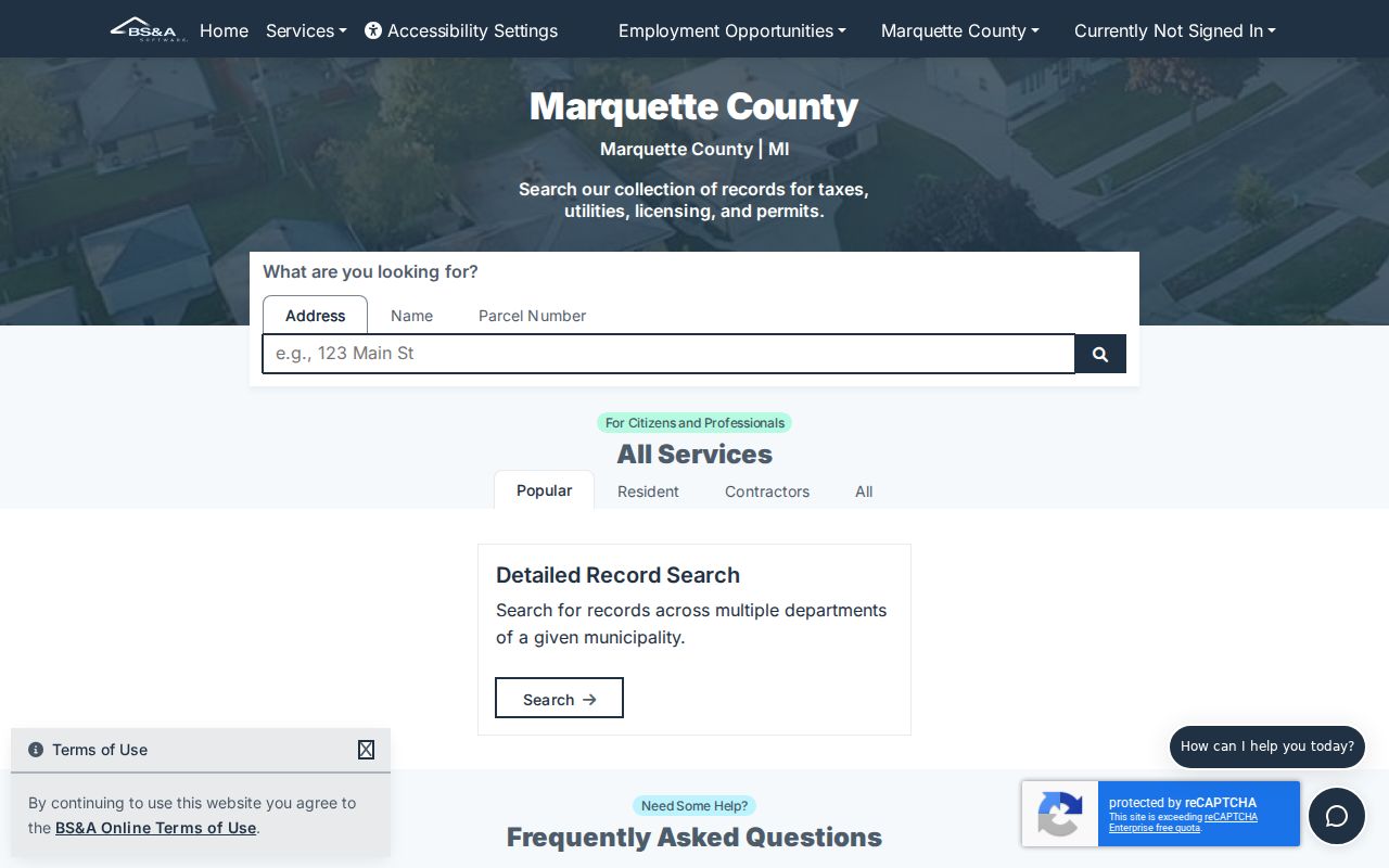
The visible categories support the address-to-permit handoff, while the actual record fields and coverage must be confirmed in the live Marquette result.
For city zoning, engineering, or right-of-way material that is not publicly indexed, send a focused request by address and date range through the City of Marquette FOIA route. Michigan FOIA, MCL 15.231 et seq., applies to existing non-exempt records and does not require the City to create an answer or a new address list.
Bridge Marquette Street Name Changes
Old street labels can break an otherwise sound address search. A Mining Journal history reports that Superior Street became Baraga Avenue, Mount Vernon Avenue became Hewitt Avenue, Specular became College Avenue, Hematite became Kaye Avenue, and Walnut became part of Lakeshore Boulevard. It also notes that older sidewalk stamps can preserve a former name. Search the old and modern labels together when checking deeds, directories, and residence references.
There is no verified exact date for a citywide Marquette renumbering. That absence matters. Do not assign an old entry a modern number by guesswork. Bridge the record with an old street name, a cross street, the lot or block, the legal description, a nearby parcel, and the directory year. The local street-name account is a starting point for aliases, not a substitute for a parcel match.
Myth: A different street name means the old address is unrelated. In Marquette, a name change can be the reason two records appear not to connect. The durable land description is the test.
Marquette Historical Street Evidence
For a past household, use local sources after the land trail is established. Peter White Public Library's Local History and Genealogy resources hold directory, newspaper, map, and research paths. The Marquette Regional History Center describes address-filed photographs, residence indexes, directories, Sanborn maps, and Mining Journal materials. Historic assessment rolls cover 1868 through 1940, with later tax-roll runs identified in state archive record groups.
Sanborn maps for Marquette span 1884 to 1946. They can show a building footprint, materials, use, and street context, but not a household name. The Mining Journal run is on microfilm from 1868 to 2019, with a digital run through February 1989 at PWPL. A historical directory or newspaper reference should be kept with its publication date because it may lag an actual move or transfer.
Note: Fragile address-filed photographs and maps at the history center may have reproduction limits or fees, so ask staff before planning a copy request.
Limits of a Marquette Street Directory
A Marquette street directory can document land, recorded parties, and dated historical references. It cannot provide a verified household list for every address. A tax-mailing address is not a residence. A homestead indicator can support an assessed owner-occupancy claim for a tax period, but not prove who is present now. GIS shows geometry, not occupants. MVIC is an individual lookup that requires a first name, last name, birth month, birth year, and ZIP, not a browsable street roster.
Michigan voter materials withhold driver-license or state-ID numbers, month and day of birth, phone, email, digitized signatures, and the last four Social Security digits. The Qualified Voter File separates public and protected fields. Michigan's Address Confidentiality Program, created by 2020 PA 301 and codified at MCL 780.851 et seq., can provide eligible participants with a substitute address. A missing or substituted location may be a protection feature, not a search error.
Lawful use. Use Marquette address records for personal, lawful research, family history, property questions, or civic transparency. Public availability never permits stalking, harassment, intimidation, or attempts to expose a protected address.